Quick Facts
- Top Trail (Strenuous): Gros Morne Mountain (17km)
- Top Trail (Easy): Coastal Trail (6km)
- Unique Geology: Tablelands (Half-billion-year-old Earth's Mantle)
- Best Hub: Rocky Harbour
- Key Warning: Mountain trails closed May 1 to June 27 annually
- Accessibility: 25 mins from Deer Lake Airport (YDF)
Experience Gros Morne hiking in 2026, a UNESCO World Heritage site that offers an uncrowded alternative to the Rockies. From walking on the Earth's mantle to scaling glacial fjords, this guide covers everything you need. Gros Morne National Park offers a world-class hiking experience with more than 100 kilometers of trails ranging from easy coastal strolls to the strenuous 806m-elevation Gros Morne Mountain summit. Unlike the crowded paths of Banff, hiking in Gros Morne provides a raw, untamed encounter with geological history, where you can walk directly on the Earth’s mantle in the Tablelands or view deep glacial fjords at Western Brook Pond.
I’ve stood on peaks around the world, but there is something fundamentally different about the air in western Newfoundland. It’s heavy with salt, light with the scent of spruce, and carries a quiet that most mountain ranges lost decades ago. When people ask me for a Gros Morne hiking recommendation that beats the tourist crowds of the west, I always tell them the same thing: this isn't just a park; it's a tectonic collision frozen in time. Covering 1,805 square kilometers of remote wilderness, it is a place where you can literally feel the Earth’s history under your boots.
The South: Walking on the Earth's Mantle
The southern portion of the park, specifically the area surrounding the Woody Point village, is home to a landscape that looks like it belongs on Mars. This is the Tablelands, a flat-topped mountain of orange rock that was once deep beneath the ocean floor. Geologically, it’s peridotite rock formations that were thrust upward millions of years ago when continents collided. Very few plants can grow here because the soil is toxic to most life, creating a barren, majestic orange desert.
When I first tackled the Tablelands hiking Newfoundland trails, I was struck by the silence. Because there is so little vegetation, sound doesn't echo—it just disappears. The Tablelands Mantle of the Earth Trail is a 4km loop that is accessible to almost anyone. It’s mostly flat and follows an old roadbed, making it one of the better choices when planning a hiking trip to Gros Morne National Park if you want high-impact views with low-impact effort.
Trail at a Glance: Tablelands Mantle of the Earth Trail
- Distance: 4km return
- Elevation: Minimal
- Level: Easy
- Time: 1.5 - 2 hours
If you want something deeper, the Green Gardens trail Gros Morne coastal hike guide usually highlights the dramatic transition this area offers. You start on that volcanic, barren plateau and descend through lush forests down to the edge of the Gulf of St. Lawrence. Here, you’ll find sea caves, volcanic pillows, and even sheep grazing on the cliffside meadows. It is a long climb back up, so bring plenty of water and your best knees.
The North: Fjords, Forests, and Summits
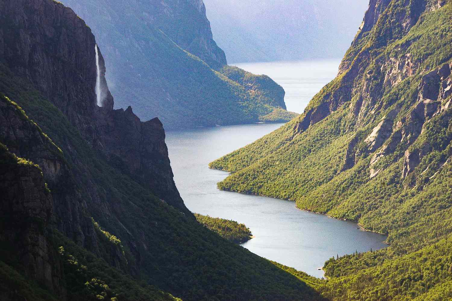
While the south is alien and barren, the north is the Gros Morne most people see in postcards. This is where the glacial fjords cut deep into the Long Range Mountains. If you are looking for those iconic bird’s-eye views of Western Brook Pond, you have to be ready to work for them.
The Gros Morne Mountain summit tips I give my readers always start with one word: preparation. This is a 17km loop that gains 806m in elevation. It is a strenuous day-long trek. The first 4km takes you through thick tuckamore forests—stunted, wind-blown trees that look like they’ve been groomed by a giant. Once you hit the base of the mountain, the "Gully" begins. It’s a steep scramble over loose rock.
Trail at a Glance: Gros Morne Mountain (James Callaghan Trail)
- Distance: 17km loop
- Elevation: 806m gain
- Level: Strenuous/Difficult
- Time: 6 - 8 hours
Reaching the top feels like standing on the roof of the Atlantic. From the summit, you can see the deep troughs of the fjords and the shimmering Gulf of St. Lawrence. Be warned: the weather here changes in minutes. I’ve seen hikers start in sunshine and end in a white-out fog. Always pack a shell layer and sturdy boots. Also, remember that this trail is closed from May 1 to late June to protect the caribou and ptarmigan during their sensitive nesting and calving season.
For those who want the fjord views without the vertical scramble, the Western Brook Pond area offers a boat tour, but the hike to the dock is a pleasant, flat walk through wetlands. It’s part of the extensive Gros Morne National Park trail systems that allow you to see the scale of the cliffs without needing a climbing harness.
Family-Friendly and Easy Coastal Paths
Not every day in Newfoundland needs to be a mountain-slayer. Some of my favorite memories in the park involve the simple, salt-sprayed walks along the coast. The best easy coastal trails in Gros Morne for families are found near Green Point and Rocky Harbour.
The Coastal Trail is a 6-kilometer return path that follows what used to be a winter mail road. It’s almost entirely flat and hugs the shoreline of the Gulf of St. Lawrence. It’s the perfect place to let kids explore tide pools or to watch the sunset. You’ll weave in and out of the "tuckamore" trees, which provide a natural windbreak from the North Atlantic gusts.
Trail at a Glance: The Coastal Trail
- Distance: 6km return
- Elevation: Flat
- Level: Easy
- Time: 1.5 - 2 hours
If you find yourself near the Trout River area at the southern end of the park, don’t miss the sunset hiking at the Trout River Pond trail. There is an imposing wooden staircase that feels like it’s leading to the sky, offering panoramic vistas of the water as the sun dips below the horizon. The light hits the orange rocks of the Tablelands across the water, making them glow like they’re on fire. This area provides a great Gros Morne vs Banff for less crowded hiking comparison; you can often have these world-class sunset views entirely to yourself.
Logistical Planning: Getting There and Staying Safe
The biggest mistake I see travelers make when planning a hiking trip to Gros Morne National Park is underestimating the driving. The park is split by Bonne Bay. Living in Rocky Harbour or Norris Point puts you in the heart of the North, but getting to the Tablelands in the South requires a one-hour drive around the bay. Alternatively, you can take the Bonne Bay Water Shuttle, which is a fantastic way to see the park from the water and save time on the road.
Safety in this remote wilderness is paramount. This isn't a manicured city park. You are in moose country. With over 5,000 moose estimated to be in the park, your Gros Morne hiking safety tips for wildlife and terrain must include staying alert on the trails and on the roads, especially at dusk. While black bears are present, they are generally shy, but always practice proper food storage if you are doing any backcountry trekking.
Regarding gear, I never step onto a trail here without:
- Waterproof shells: Even on a clear day, the "Newfoundland mist" can soak you to the bone.
- Mapping tools: Cell service is non-existent on the Long Range Traverse or the back side of Gros Morne Mountain. Use a dedicated GPS or a high-quality topographical map from the Parks Canada visitor center.
- Sturdy Footwear: The peridotite and scree slopes will chew through thin sneakers in a single afternoon.
The park was designated a UNESCO World Heritage Site in 1987, and when you stand on the edge of a 600-meter cliff looking down into a fjord created by a glacier 10,000 years ago, you understand why. It's a place that humbles you. Whether you are walking the flat Coastal Trail or pushing your limits on the mountain summit, Gros Morne demands respect and rewards you with views that stay with you for a lifetime.
FAQ
What are the best hiking trails in Gros Morne National Park?
The "best" trail depends on your fitness, but the "Big Three" are Gros Morne Mountain for summit views, the Tablelands for unique geology, and Green Gardens for coastal cliffs. For those seeking solitude, the Lookout Trail near Woody Point offers a high reward-to-effort ratio with views of the entire bay system.
How difficult is the Gros Morne Mountain hike?
It is considered strenuous and very difficult. The 17km trail includes a steep rock scramble called a scree slope. You should be in good physical condition and prepared for a 6 to 8-hour day. The descent is also hard on the knees as it follows a rough, rocky path down the back of the mountain.
Do you need a permit to hike in Gros Morne?
You need a valid Park Pass to enter and use any of the trails in the park. If you plan on doing multi-day backcountry trekking, like the Long Range Traverse, you must attend a safety briefing and obtain a specific backcountry permit from Parks Canada. Day hikes generally only require the standard entry pass.
Is hiking in Gros Morne safe regarding wildlife?
Yes, provided you are smart. Moose are the most common large animal and can be aggressive if cornered, especially during the fall rut. Keep your distance. Black bears live in the park but usually avoid humans. Making noise while you hike and properly storing food are the best ways to stay safe.
When is the best time of year to go hiking in Gros Morne?
The prime hiking season is from late June to late September. Before June, many high-elevation trails are closed for animal conservation or are still covered in deep snow. September offers cooler temperatures and stunning fall colors, though the weather can become more unpredictable.
What is the easiest hike in Gros Morne National Park?
The Coastal Trail and the Tablelands Mantle of the Earth Trail are the easiest options. Both are relatively flat, well-marked, and offer world-class scenery without requiring significant elevation gain. They are perfect for families, seniors, or those looking for a recovery day after a big mountain climb.